Presentation of Sustain-COAST result at the 12th World Congress of the European Water Resources Association (EWRA) on Water Resources and Environment, under the theme "Managing Water-Energy-Land-Food under Climatic, Environmental and Social Instability".
-
 KARATZAS_FINAL_PRESENTATION.pdf Managing Water-Energy-Land-Food under Climatic, Environmental and Social Instability
Sustain-COAST participated with an abstract to Sustain Valencia 2022 Conference: Sustainable Groundwater Management
Building on the success of the 2019 Chapman conference “Quest for Sustainability of Heavily Stressed Aquifers at Regional to Global Scales” held in Valencia and the well-attended 2021 AGU annual meeting hybrid session “Prospects for Sustainability of Heavily Stressed Aquifers: Impediments and Opportunities”, SustainValencia2022 was organised at the Technical University of Valencia (UPV) on October (6-8) with the theme “Achieving Sustainable Groundwater Management: Promising Directions and Unresolved Challenges”. During the event Sustain-COAST project was presented by UfZ partner.
The book of abstracts can be downloaded from here.
Find below Sustain-COAST abstract.
A multi-decadal assessment of groundwater levels in the Iberian Peninsula
Nahed Ben-Salem1 , Emmanouil Varouchakis2 , Robert Reinecke4 , J. Jaime GómezHernández5 , Nadim K. Copty6 , George P. Karatzas3 , Michael Rode1 , Seifeddine Jomaa1 1 Department of Aquatic Ecosystem Analysis and Management, Helmholtz Centre for Environmental Research-UFZ, Magdeburg, Germany 2 School of Mineral Resources Engineering, Technical University of Crete (TUC), Greece 3 School of Chemical and Environmental Engineering, Technical University of Crete (TUC), Greece 4 Institute for Environmental Science and Geography, University of Potsdam, Potsdam, Germany 5 Institute of Water and Environmental Engineering, Universitat Politècnica de València, Valencia, Spain 6 Institute of Environmental Sciences, Bogazici University, Istanbul, Turkey
Keywords: groundwater modelling, geostatistical methods, Iberian Peninsula
Abstract.
Growing water demand in the Mediterranean region has increased groundwater exploitation, necessitating urgent and efficient groundwater management. Due to the semi-arid climatic condition and the spatial unevenness in recharge, groundwater dependency for different water uses has increased, which presents a severe challenge for its sustainability. Understanding periodic groundwater natural cycles and analyzing persistent water-level trends require long time-series data which rarely exist. Hence, the long-term dynamics of steadystate groundwater levels need to be evaluated for better water resource management and a new action plan. This study aims to assess the multi-decadal changes in steady-state groundwater levels at a regional scale by combining ensemble modelling, essential explanatory variables, and in-situ observations. First, the outputs of three global gradientbased groundwater models were compared to observed groundwater levels in the Iberian Peninsula derived from historical data of 3822 piezometers covering 55 years (1965-2020). Second, the spatial multi-decadal changes in groundwater levels under varying climate conditions were investigated using various geostatistical methods, in different time frames. We argue that a sound combination of essential explanatory variables with in-situ data can explain better the multi-decadal changes in groundwater levels in the region. A temporal-scale investigation is crucial for resolving a variety of water-resource issues which include groundwater availability and changes in groundwater quantity. To this end, a database of comprehensive groundwater data and essential explanatory variables (i.e., elevation, rainfall, and a steady-state groundwater model) was developed and analyzed. In this investigation, we describe the combination of ensemble modelling, in-situ data, and essential explanatory variables as an innovative framework for estimating groundwater potential across the Iberian Peninsula. Such a comprehensive methodology will generate and evaluate long-term data to understand historical groundwater variability. The outputs of this study help to develop strategies for sustainable groundwater exploitation, preservation, and management, especially in a region known as a climate change hotspot.
This work was supported by the German Federal Ministry of Education and Research (BMBF, Germany, Grant 01DH19015) under the Project Sustain-COAST, co-funded by the EU PRIMA 2018 programme.
Sustian-COAST at the 14th International Conference on Hydroinformatics Water INFLUENCE − Water INFormatic soLUtions and opEN problems in the cycle from Clouds to ocEan 4-8 July 2022, Bucharest, Romania
Modeling the groundwater flow of a coastal Mediterranean region aquifer under climate change scenarios.
Paraskevas Diakoparaskevas1 , Ioannis Trichakis1,3, Chris Goumas1 , Emmanouil Varouchakis2 and George P. Karatzas1,*, Marco D’Oria4 , Valeria Todaro4
Short abstract. Climate change is adding pressure to the coastal areas and their aquifers. Numerical tools are widely used for modeling and monitoring the aquifers’ condition considering climate change scenarios. This work is referred to the Malia area in Crete, Greece. The tool that was used in this work is FEFLOW software. Climate change scenarios were used to assess potential effect on groundwater budget confirming that there will be a depression in the groundwater level. The Regional Climate Models that were used are based on 2 Representative Concentration Pathways (RCP 4.5 and RCP 8.5). Keywords. Coastal Aquifer, FEFLOW, Malia area.
Sustain-COAST participated with an abstract at the 7th INCSOS International Congress of Social Sciences
The 7th INCSOS International Congress of Social Sciences was held on 2-3-4 June 2022 in Baku, the capital of the Republic of Azerbaijan.
Mersin University participated at the event and presented an abstract (see below).
Evolution of Groundwater Quality in Mediterranean Basins Under the Pressure of Changing Climate Conditions; A Case Study of Erdemli-Mersin Aquifer
This study aimed to determine the groundwater quality of the Erdemli Coastal Aquifer (ECA) located in the west of Mersin province in the Mediterranean Region, which is under the intense influence of climate change. Within the scope of the study, water sampling was carried out for two periods (August 2020 and June 2021). The physical parameters, major anion, and cation contents of groundwater were determined by multiparameter, spectrophotometer, and ICP-MS methods respectively. The suitability of groundwater for use as drinking water and its pollution status was determined using the Water Quality Index (WQI) and Heavy Metal Evaluation Index (HEI). The World Health Organization (WHO) standards were taken to reference the drinking water limit values in the indices. According to the WQI results, two of the samples belonging to the first period are in the ̎very bad water ̎ class, three of them are in the ̎bad water ̎ type, and the other samples are in the ̎good water ̎ and ̎excellent water ̎ class. One of the samples belonging to the second period is in the ̎very bad water ̎ class, the other two in the ̎bad water ̎ class, while the other examples are in the ̎good water ̎ and ̎excellent water ̎ class. According to the HEI results, ̎moderate pollution ̎ was observed in two samples in the first period, and ̎low pollution ̎ was observed in the other samples, while ̎low pollution ̎ was observed in all of the samples in the second period. According to the index (HEI) values calculated based on heavy metals, Ni and Fe in samples with ̎moderate pollution ̎ level exceeded the reference (WHO) standard values. As a result, it has been determined that the quality of some waters in the study area is not suitable for public health.
Keywords; Climate change, Mediterranean, Water quality index, Mersin, Public health
Sustain-COAST and InTheMED PRIMA projects participated with 2 abstracts at the Scientific Assembly of the International Association of Hydrological Sciences (IAHS 2022) in Montpellier May-June 2022
Sustain-COAST participation at EGU General Assembly 2022 23–27 May 2022
New Sustain-COAST publication
Efficient treatment for tannery wastewater through sequential electro-Fenton and electrocoagulation processes
Abstract
This work aims to study the ability of using single and sequential electro-Fenton (EF) and electrocoagulation (EC) processes in order to treat tannery wastewater. The first method (EF) was run with an air diffusion cathode for H2O2 generation and boron–doped diamond (BDD) as an anode. The second method (EC) was conducted with mild steel electrodes. The applied processes' performance was monitored by the removals of chemical oxygen demand (COD) along with the total Cr in addition to the electric energy consumption (EEC). To achieve the allowable discharge limits in aquatic media, a hybrid 2 h EF-5 h EC process was applied to treat tannery wastewater, based on the optimization results of every single method, achieving (88.1 ± 4.8)% COD removal rate with total elimination of Cr. In addition, the results of other parameters evolution such as pH, turbidity and the concentration of ions were discussed. As a result, the global EEC of the hybrid treatment was reduced to about 1.7 times. Finally, precipitate and sludge generated at the end of each treatment were examined by X-Ray Diffraction (XRD) analysis to determine their crystalline structure for valorization or reuse possibilities.
Deliverable 3.3a: Report on cost efficiency and cost-benefits of selected preventive scenarios
-
Deliverable 3.3a: Report on cost efficiency and cost-benefits of selected preventive scenarios This report presents the main activities of the WP3 team on the project Sustain-COAST in the topic cost efficiency and cost-benefits of selected preventive scenarios. Efforts were spent to identify the cost benefit use of water resources and to mitigate groundwater depletion and degradation in each case study of the four Sustain-COAST demonstration sites. The choice of the appropriate mitigation technique in each case study mainly depends on the site conditions. This task is presented as a pilot for each demonstration site and will be updated in part b (D3.3b), considering local data and the final suggestions by all stakeholders in each case study. To this end, the full cost-benefit methodology is presented, and the optimal options for managed use of groundwater and surface water is presented for each case study. The mapping of those options is a dynamical process and will be adjusted over the course of the project, where key stakeholders can be added at a different stage to enrich the multi-stakeholder partnership process. The provided information will give insights into assessing the sustainability of the current and future groundwater management strategies. This analysis will identify the impact of the adequate mitigation option considering sustainable water resources availability, management, and pollution risks.
3rd Euro-Mediterranean Conference for Environmental Integration: "Surface water quality assessment of Wadi El Bey, Tunisia"
Designing innovative local water governance using a living lab: Wadi el Bey Case study- Tunisia
Thuraya Mellah1,2, Hatem Baccouche2 , Salah Jellali3 , George P. Karatzas4 , Pier Paolo Roggero5,6 , Hanene Akrout2
1 Higher School of Digital Economy(ESEN)- University of Manouba
2 Wastewater and Environment Laboratory, Water Research and Technology Center CERTE, P.O. Box 273, Soliman 8020, Tunisia
3PEIE Research Chair for the Development of Industrial Estates and Free Zones, Center for Environmental Studies and Research, Sultan Qaboos University, Al-Khoud 123, Muscat, Oman
4 Department of Environmental Engineering, Technical University of Crete, Greece
5 Dipartimento di Agraria, University of Sassari, Viale Italia 39 07100 Sassari Italy
6 Nucleo di Ricerca sulla Desertificazione, University of Sassari, Viale Italia 39 07100 Sassari Italy
ABSTRACT
In this work, the living lab is used to co-design innovative institutional arrangements to govern and sustainably manage local water resources. The co-creation process is carried out according to a decentralized participatory and actor-centered approach and using the social learning concept. The stakeholders involved in water management, including local authorities, users, citizens and researchers, are brought together to analyse the sustainability issues of the social-ecological system at the Wadi El Bey watershed level. The researchers have designed the Wadi el Bey living lab as a social arena where the local actors can meet. At the first stage of this process, and until the consensus on the new governance is reached, the actors are guided via various activities such as participatory mapping, inversing role, and expressing motivations and expectations. These interactive activities aimed to build a relevant, comprehensive, and common vision on the issues related to the management of local groundwater resources.
KEYWORDS: innovative governance, sustainability, living lab, Wadi el Bey.
Living Labs towards sustainable groundwater management: case study in Malia, Crete, Greece, EGU General Assembly 2021, online, 19–30 April
George Karatzas1, Anthi-Eirini Vozinaki1, Ioannis Trichakis1,2, Ioanna Anyfanti1, Christina Stylianoydaki1, Emmanouil Varouchakis1, Christos Goumas1, Pier Paolo Roggero3, Thuraya Mellah4,5, Hanene Akrout5, and Seifeddine Jomaa6
- 1Technical University of Crete, School of Environmental Engineering, Environmental Engineering, Chania, Greece (karatzas@mred.tuc.gr)
- 2European Commission, Joint Research Centre (JRC), Italy
- 3University of Sassari (UNISS), Italy
- 4Higher School of Digital Economy (ESEN), University Manouba
- 5Wastewaters and Environment Laboratory, Centre of water research and technologies (CERTE), University of Carthage
- 6Department of Aquatic Ecosystem Analysis and Management, Helmholtz Centre for Environment Research - UFZ, Magdeburg, Germany
This work carries the social learning process out via Living Labs in order to construct a common vision on sustainable groundwater management. In this process, the scientific and local knowledge are integrated. This study is part of Sustain-COAST project co-funded by PRIMA programme. Stakeholders’ active engagement is realized via Living Labs, which are participatory actions that encourage the dialogue among private and public actors, create institutionalized space for discussion and vision sharing, and analyze the stakeholder-suggested mitigation options.
A stakeholder mapping took place, that is the list of all the key groups, organizations, and people involved to water management in the study area. Further analysis was carried out to better understand stakeholders’ roles and perspectives, within the first Living Lab, organized in Malia. 55 stakeholders interacted gathered, including water users, policy makers, local and regional authorities, water management and supply associations, socio-ecological and cultural associations, NGOs, citizens, technicians, external experts, scientists.
Stakeholders got involved in social learning actions, knowing each other, expressed their motivations and expectations to participate in the first Living Lab and the project. Afterwards, a participatory session followed by implementing digital ICT tools (Mentimeter App.), which is an opinion survey technique that might improve societal awareness and stakeholders’ active engagement in water management. Afterwards, an interactive participatory map activity took place, which enabled the study site’s characterization according to key-stakeholders’ perception, knowledge, and expertise on water management issues in the area. Stakeholders collaborated in groups and filled maps of the study area with significant spatial data and information. Participants were asked to express their common vision on Malia in an entertaining puzzle activity.
The aforementioned interactive sessions enabled the extraction of the raised water issues in Malia as well as the suggestion of possible options . The need for sustainable and balanced development taking into account principles of law and equal accessibility for all was specifically noted by stakeholders. Stakeholders evaluated the Living Labs as an innovative interactive and interesting way of exchanging views among institutions and citizens, through participation and technological means. Living Labs are expected to provide significant information exchange among institutions and actors and provide realistic and socially acceptable suggestions for the local community.
Stakeholders are directly involved and motivated to maintain their active engagement in a long-lasting process via future Living Labs in Malia. Such actions increase governance capacity by addressing people’s skills in jointly decision-making and engaging stakeholders in a social learning process through participation. Actions that encourage dialogue among different actors and use innovative mediation techniques form the best options to improve and integrate water governance.
Keywords: Living Labs; Innovative governance; Water resources management; Stakeholder mapping; Social learning processes; Stakeholders’ engagement
The PRIMA programme is an Art.185 initiative supported and funded under Horizon 2020, the European Union’s Programme for Research and Innovation.
The project is funded by the General Secretariat for Research and Technology of the Ministry of Development and Investments under the PRIMA Programme. PRIMA is an Art.185 initiative supported and co-funded under Horizon 2020, the European Union’s Programme for Research and Innovation.
Groundwater assessment in the Mediterranean region: Regional modelling and in-situ data across scales, Solicuted talk, EGU General Assembly 2021, 19-30 April
Ben-Salem, N., Reinecke, R., Gómez-Hernández, J. J., Karatzas, G., Rode, M., and Jomaa, S.
Abstract:
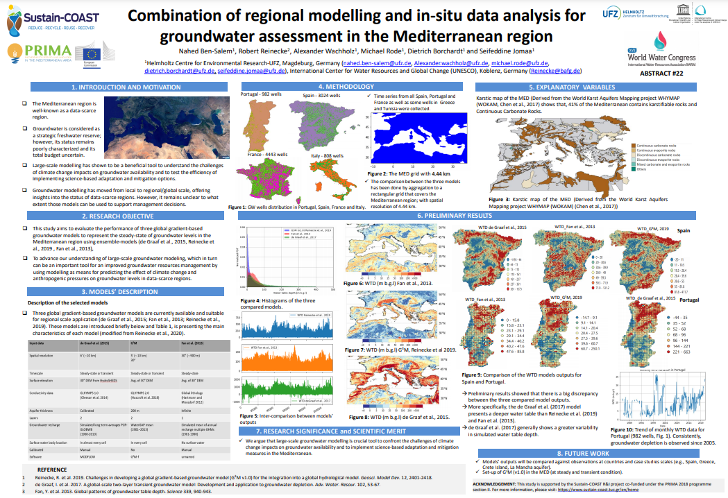
Groundwater is a valuable resource throughout the world. It supplies the needs of many sectors everywhere. Providing high spatial resolution groundwater data is important for climatic, hydrological and agricultural applications, to ensure sustainable groundwater management. The scarcity of high-resolution groundwater data over large scales at the required accuracy is a significant limitation for such applications. This study was undertaken in the Mediterranean region, which is recognized as one of the world's most sensitive regions to water scarcity due to both climate change and consistently increasing anthropogenic pressures. Groundwater is considered a strategic freshwater reserve in the Mediterranean region; however, its status remains poorly characterized. This study investigates the feasibility of downscaling outputs of three global groundwater models (Reinecke et al. (2019), de Graaf et al. (2017) and Fan et al. (2013)) to higher resolution.
Steady-state results of the three models were compared with in-situ groundwater level observations, and an aggregation method was developed for downscaling. Observations from a long-term groundwater monitoring network over different regional studies around the Mediterranean were employed. Results showed that there is a significant discrepancy between the three compared model outputs. More specifically, the de Graaf et al. (2017) model presents a deeper water table than Reinecke et al. (2019) and Fan et al. (2013), while de Graaf et al. (2017) generally shows more significant variability in simulated water table depth. A detailed comparison between simulated and measured water table depth of different Mediterranean aquifers having different climatic, geologic and anthropogenic conditions will be presented.
The results of this work will contribute to advance the understanding of how to combine large-scale groundwater modelling with local in-situ data as a crucial tool to improve groundwater management in data-scarce regions.
This work was supported by the German Federal Ministry of Education and Research (BMBF, Germany, Grant 01DH19015) under the Project Sustain-COAST, co-funded by EU PRIMA 2018 programme.
Combination of regional modelling and in-situ data analysis for groundwater assessment in the Mediterranean region. AGU Fall Meeting 2020 01-17 December
Ben-Salem, N., Reinecke, R., Wachholz, A., Rode, M., Borchardt, D., and Jomaa, S.
Abstract:
The Mediterranean region is recognized as a climate change and anthropogenic pressures hotspot, especially with the high seasonality of precipitation and increased water demands. The coastal areas, in particular, are significantly vulnerable to the effect of this critical situation. In such conditions, groundwater plays a fundamental role in water security in the Mediterranean region. Groundwater is considered as a strategic freshwater reserve. However, its status remains poorly characterized, and its total budget uncertain.
In this study, we argue that large-scale groundwater modelling has shown great potential for improvement of our physical understanding of groundwater systems functioning and to the guidance of implementing science-based adaptation and sustainable mitigation measures in the Mediterranean.
In recent years, groundwater modelling has moved from local to regional/global scale, offering insights into the status of data-scarce regions. However, it remains unclear to what extent those models can be used to support management decisions. This study aims to evaluate the performance of three global gradient-based groundwater models to represent the groundwater levels at steady-state and transient regimes in different Mediterranean aquifers.
In this investigation, the groundwater models of Fan et al. (2013), de Graaf et al. (2017), and Reinecke et al. (2019) are used. Comparison between the groundwater level predictions of the three models was conducted. Then, comparison between the water table depths simulated by each model with the corresponding in-situ data in three case studies: La Mancha aquifer in Spain, an island aquifer in Crete, Greece and the Cap Bon Peninsula in Tunisia, were performed.
Preliminary results showed that there is a large discrepancy between the three compared model outputs. More specifically, the de Graaf et al. (2017) model presents a deeper water table than Reinecke et al. (2019) and Fan et al. (2013), while de Graaf et al. (2017) generally shows greater variability in simulated water table depth.
This study contributes in enhancing the role of regional-scale groundwater modeling as an important tool in assessing and predicting changes in groundwater levels in data-scarce regions, under considerable climate variability and increasing anthropogenic pressures.